Technologische Gefahren
Dam failures
Prepared by GHHD – European Centre on Geodynamical Risks of High Dams (Tbilisi, Georgia) & the Editorial Board

As emphasized by the International Commission on Large Dams in a 2007 report, dams will remain a crucial aspect of human development in the 21st century as water management will be a major challenge in particular as a result of climate change (increasing the irregularity of water supply) and population growth (increasing demand).
As in the case of any critical engineering infrastructure, the erection of dams is a potential source of hazards: the failure of a large storage dam would cause tremendous damage to infrastructure, the environment and the social network and result in a setback in the development of the surrounding region.
Dam safety is therefore a foremost prerequisite for the sustainable development of a storage project or for the sustainable operation of an existing storage facility. A technology that is unsafe has no future, and the history of dam construction, spanning over several thousand years, has shown that safety is the basis of sustainability.
Dams are artificial barriers that can impound water or any liquid for the purpose of storing or controlling water. Dams have been in existence for many thousand years. They were erected by early civilizations in ancient China, Mesopotamia, Persia, Egypt and India. Dams, as well as dikes (long walls of earth), are also used for defending habitats and land from river floods, i.e. for disaster risk reduction.
Besides their traditional role in irrigation, dams bring great benefits to mankind in important domains such as:
i. Water supply for domestic and industrial use
A reliable source of water is needed both to sustain existing civilization and to support future growth. Dams contribute significantly to fulfilling our water supply requirements. To accommodate variations in the hydrologic cycle and avoid the complete disappearance of groundwater, dams and reservoirs are needed to store water and subsequently provide more consistent supplies during shortages.
ii. Agricultural demand for irrigation and food supply
“Food grows where water flows” is a well-known saying in many regions of the world. According to estimations, 80% of the additional food production required by the year 2025 will have to come from irrigated land.
iii. Flood control
Dams and reservoirs can be effectively used to regulate river levels and flooding downstream of the dam by temporarily storing the flood volume and releasing it later. Lowering of the reservoir level to create more storage before the rainy season eliminates the risk of flooding.
iv. Hydropower
Water has been used since ancient times to drive water wheels for various mechanical processes, such as grinding corn, sawing timber or driving textile mills. From the mid-19th century water power was used to produce electricity. Since water is the source, hydropower is a renewable and widely used source of electricity. What is very important is that it is a clean source of power, as it does not involve burning fuel and therefore does not pollute the environment.
v. Other purposes
Recreation, navigation improvement, fish breeding.
A dam needs several components in order to operate properly: the reservoir (lake) that stores water, the spillway (structure over or through which flow is discharged from a reservoir in order to prevent dam overflow), the outlet works and a control facility. Under normal operating conditions the water level is managed by the control facility which regulates discharges in the outlet works, consisting of a large tunnel or conduit with control gates. Under flood conditions the reservoir level is maintained by both the spillway and the outlet works.
Consequently, a dam-related emergency is a situation when the main use of dams (namely retaining water) is no longer ensured.
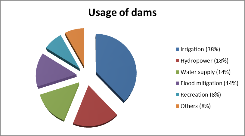
There are several different types of dams:
- embankment dams built of earth or rocks (75% of all dams are of this type);
- those built of concrete, stone, or other masonry are called gravity dams;
- arch dams or buttress dams.
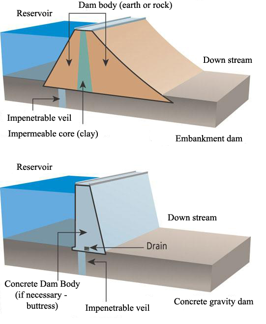
The selection of the site and type of dam involves a detailed assessment of such factors as geology, topography, foundation rocks, hydrology, seismic conditions and the need for construction materials. In narrow valleys with sound rocks it is preferable to build a concrete dam, while in wide valleys with less solid rocks it is preferable to build embankment dams. Earth embankment dams are the most common type as they partly use the material excavated during the foundation work.
As a result of exposure to a hazard, people, property, systems, or other elements present in the hazard zones are subject to potential losses – this is referred to as “vulnerability”. Disaster risk is the product of hazard and exposure – a source of human and economic losses.
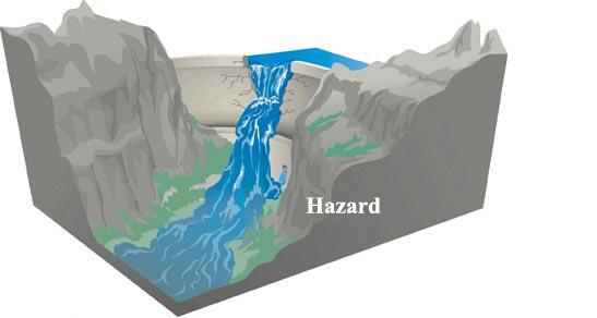
There are different types of hazards possible for large storage dams (a comprehensive overview can be found in the final report published by the World Commission on Dams in 2000):
- Earthquakes
- Landslides
- Floods
- Aging of the dam and of its components
It is necessary to distinguish between the following main types of dam-related hazards:
Natural– strong earthquakes, excess precipitation or snow melt, which cause water overtopping, or landslide occurrence, which can damage the system due to rocks falling or sliding into the reservoir.
Man-made – errors in use of dams (excessive release of water from spillway and sudden fluctuations in release of water from the operation of the power plant); terrorism; mistakes made during design or construction stages; deficiencies in building materials; aging of installations and dam materials; water quality issues in the reservoir (water-borne diseases; deterioration of water quality due to organic matter, release of hazardous substances, waste from aquaculture, etc.) affecting people, fishery and others..
Natural hazards occur due to natural large-scale processes (like earthquakes, which occur due to the movement of enormous tectonic plates) and it is impossible (in the case of earthquakes) or very difficult (in the case of landslides and floods) to prevent them.
The hazards from the natural environment are site-specific, whereas man-made hazards mainly depend on people’s behaviour and actions and are usually not site-specific. There are, moreover, a number of project-specific hazards which depend on the dam type, design, construction, shape and height, foundation conditions, seepage control, age, reservoir volume, water depth etc.
The result of such hazardous events could be dam failure and the generation of a flood wave (the latter is mainly due to either destruction of the dam or simply the overtopping of water). A further distinction needs to be made between the technical hazards expected in a new project and hazards affecting an existing project.
In the world there are currently about 50,000 large dams with reservoirs. Large dams are defined as those which are 15 meters high from the foundation to the top, or, if the height is between 5 to 15 metres, those which have a reservoir capacity of more than 3 million cubic meters.
The largest dam in the world, which stores an enormous volume of water, is the Three Gorges Dam (China):
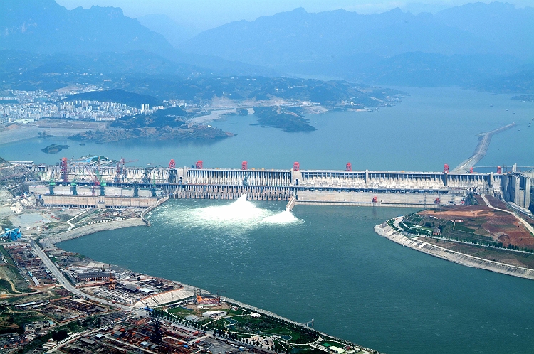
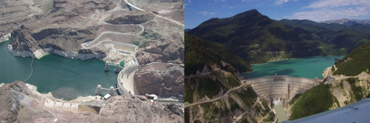
Large dam-related disasters with large consequences can therefore occur anywhere in the world where dams are erected.
Many dams are erected in narrow canyons, which as a rule result from active tectonic motion. In turn, active tectonics means that the area (and dams) are prone to the impact of earthquakes, large landslides and tectonic creep.
Large floods and human activities can also damage dams. It will be recalled, for example, that a large disaster occurred in Vajont (Italy) due to landslide, that dams were destroyed during World War II in Germany, and that a number of dams failed in India and China due to heavy floods.
However, there are now a number of new projects with a much larger damage potential than the dams mentioned above. Due to population growth, economic development etc. the risks are steadily growing while safety remains unchanged.
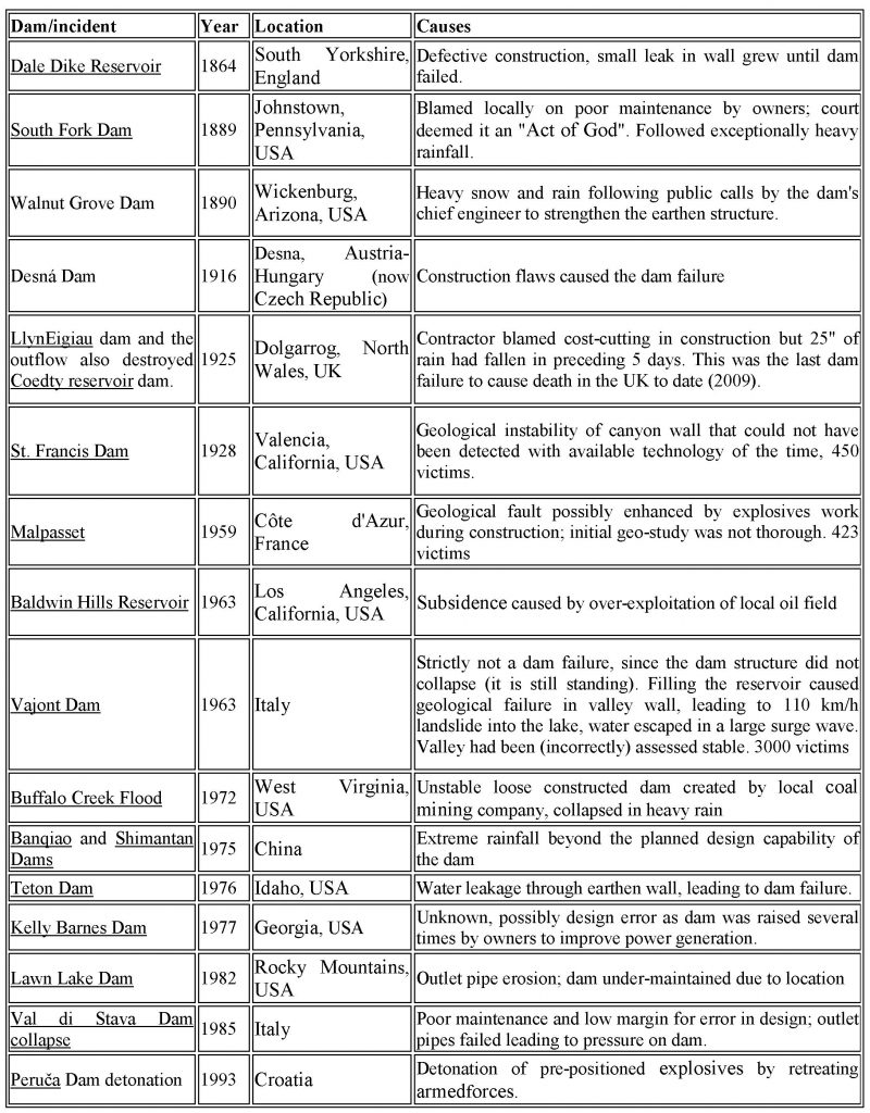
The causes of the largest dam accidents prior to 2000 are presented in the following table:
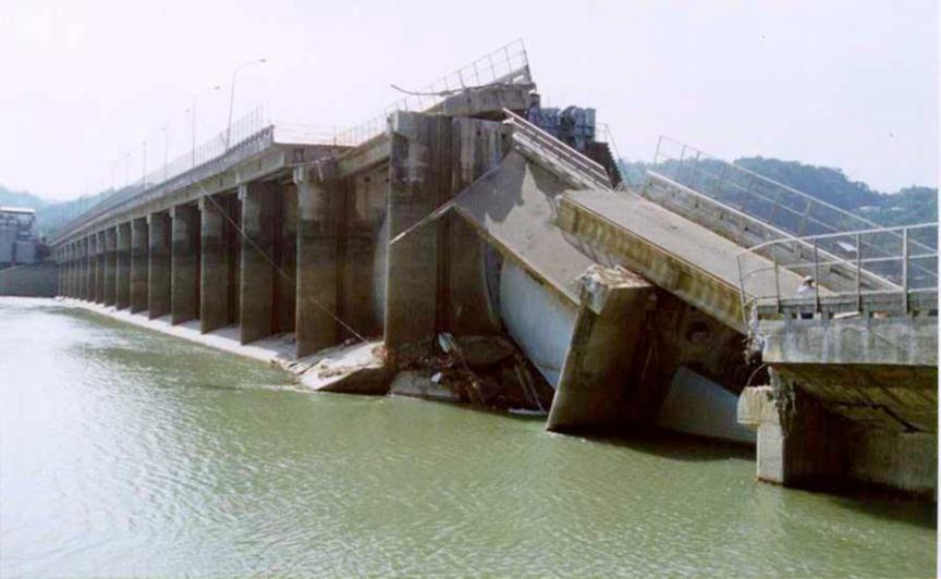
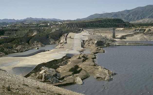
Since 2000, several major dam accidents have occurred all over the world:
- Extreme rainfall during the 2002 European floods affected the Soběnov dam (Czech Republic)
- Unexpectedly heavy rain in 2005 affected the Shakidor Dam (Pakistan)
- A computer/operator error in 2005 affected the Lesterville dam (Missouri, United States); here gauges intended to mark the dam as full were not respected and the reservoir continued to fill.
- Poor maintenance and heavy monsoon rain in 2009 affected the Taum Sauk reservoir in Tangerang, Indonesia
- A turbine accident in 2009 affected the Sayano–Shushenskaya dam, Russia
Dam failure has a whole spectrum of consequences and creates new types of hazards: environmental, ecological, economical, financial, social, socio-economic, political, cultural heritage, resettlement of indigenous people etc.
Dam breakage generally leads to considerable human losses because the area below a dam is usually densely populated. The table below mentions some of the dam-related emergencies with largest human losses:
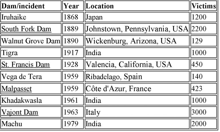
The environmental impact of dam breakage can be significant: flood water can cover large areas, destroying natural conditions for plants and fauna, but this is a short-term impact. Operational rules should be provided for regulating downstream flows at critical times to protect habitat.
Environmental hazards due to the erection of the dam in a river basin are even more serious as the natural water cycle can be affected. During the design of the project, mitigation measures need to be considered:
- vegetation should be cleared from the area to be flooded;
- outlet structures should optimize downstream water temperature and quality to preserve natural conditions;
- measures providing for the migration of fish and other aquatic organisms should be implemented.
Such accidents also cause substantial socio-economic losses such as loss of property, loss of production, losses due to the non-availability of the reservoir, unemployment, slow-down in economic development, etc.
Other consequences can also emerge, such as water shortage for irrigation and domestic purposes, political unrest.. Cultural heritage monuments can also be damaged as a result of strong flood waves.
Finally, the creation of a reservoir may also induce earthquakes due to the additional stress of water on the earth’s crust or the increase of pore pressure in the rocks; this effect (reservoir–induced seismicity or RIS) can be described as the triggering of a natural event by human interference.
Natural hazards are caused by large-scale processes and it is very difficult to prevent hazardous consequences for dams. The only real method of such disaster risk reduction is to design the dam in such way that it can resist or reduce the negative impact on natural forces. In the case of an earthquake, this is achieved by making a detailed study of the construction area – active faults, their seismic potential, recurrence period of earthquakes, geotechnical properties of the site and by erecting the dam so that it will withstand seismic shaking without substantial damage.
In contrast to large-scale natural hazards, man-made hazards can be reduced by timely intervention.
For example, a good real-time monitoring network measuring dam and foundation deformations can signal that the strains in the system are close to the theoretically predicted critical values, estimated in the process of dam design. In this case the operating staff of the dam can decrease the filling/discharge rate to lessen the strain rate.
One important dam-related hazard caused by human activity is the phenomenon of reservoir-induced seismicity (RIS). There are two main models of RIS:
i. impact of direct loading of the earth’s crust by lake weight;
ii. increase in pore pressure of fluid in porous geological formation.
In the first case the load can release the normal stress on some types of tectonic faults, thus decreasing the friction resistance to tectonic stresses and facilitating the slip along the fault, i.e. initiating the earthquake.
In the second case the friction resistance of the fault decreases due to the increase in pore pressure. As the pressure of the water in the pores of the rocks increases, it “lubricates” the fault’s slip planes. This activates faults, which are already under tectonic strain, but are prevented from slipping by the friction of the rock surfaces. It is still not clear whether reservoir-induced seismicity can be predicted with sufficient accuracy, which is necessary for carrying out pro-active measures.
The main hazards and the corresponding protective measures are presented in the table below:
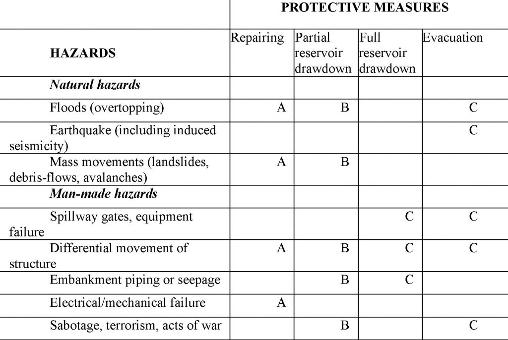
Comments on the table:
(A) The internal alert triggered by an unusual situation can be managed and controlled by the dam’s operating staff.
(B) A developing situation exists when the observed incident is clearly beginning to turn into a serious threat to the dam’s safety and the population in the downstream area. At this stage it is not yet known whether the situation can be brought under control.
(C) An imminent situation has developed when it has become clear that the progress of the incident or threat cannot be stopped, but its consequences can still be mitigated, such as the evacuation of the population in danger.
The most important issue is to protect people and to prevent loss of life; therefore, the main aim is to have safe dams. All other issues are much less relevant as long as people’s lives are not at risk. That is why the design and use of dams should take into account all possible hazards.
By means of a fully operational water alarm system and emergency planning, the loss of lives can be minimized in the case of a dam failure.
Dam-related hazards can therefore, to some degree, be reduced by safety surveillance involving:
- regular visual inspection of dam surfaces and foundations, the reservoir and other related constructions;
- continuous instrumental monitoring of the dam and foundations.
In the 1970s the time-consuming manual acquisition and processing of instrumental data was mitigated by the development of digital data-loggers and computers. The last step in the automation of monitoring systems was made recently through telemetry systems for remote acquisition of instrumental data: Automatic Data Acquisition Systems (ADAS). The idea of using monitoring systems for dam safety assessment is that continuous monitoring allows the identification of deviations of strains (tilts) in the dam body and its foundation using values providing stability of the edifice and calculated theoretically during dam design.
Training in emergency management is undeniably useful. For this purpose civil defence organisations and other institutions responsible for emergency management must hold regular training courses and people should be aware of what they have to do in the case of an emergency.
All other consequences can only be reduced effectively by land-use planning, which will take a long time to implement.
Finally, economic damage can be insured even if insurance is not the best solution; it only helps to cope with one of the many consequences of dam failure.
There are different ways in which the hazard can be predicted, namely, time-independent and time-dependent predictions (the latter are also referred to as forecasts). The time-independent predictions give information on areas prone to hazard, their expected intensities and recurrence times.
For example, seismic hazards are predicted in the following way: statistical calculations make it possible to assess the probability of occurrence (or non-occurrence) of a hazardous event of a given intensity at a given place in a given time interval: the operating basis earthquake (OBE) with a recurrence interval of 237 years should be taken into account, i.e. the structure must be able to safely withstand such earthquake without damage. The risk of flood hazard for a dam can be predicted in a similar way where the Inflow Design Flood (IDF) is used to design and/or modify a specific dam, particularly when deciding on the dimensions of the spillway and outlet works. All these assessments improve dam resistance to extreme events.
Unfortunately, it is still impossible to reliably forecast the time at which an earthquake will occur. It is easier to predict flooding, as the monitoring of meteorological parameters (including data on precipitation, temperature, and snow cover) makes it possible to calculate the volume of discharged water. Then the specific outlet works can regulate the floodwater outflow.
Landslide hazards also can be monitored by modern technology (Global Positioning System or GPS, Light Detection and Ranging Systems or LIDARS, Inverse Synthetic Aperture Radar or INSAR), which indicates the level of displacement of surface points; regular monitoring of the velocity of mass-movement gives a sound basis for predicting critical state, which can be caused, among other things, by heavy rain and intensive melting of snow cover.
Similar to seismic zoning, “flood zoning” (the plotting of inundation maps) is very useful in predicting the extent of potential flooding, the height of water and the time of front wave arrival. It is possible to calculate the time-space flood scenario more precisely, using detailed digital elevation maps.
Many dam-related hazards can be avoided by proper geological, geophysical and engineering investigation of future dam location.
In order to assess dangers correctly, the most important things to be taken into account are:
- active tectonic faults;
- landslides and slope stability;
- high permeability of the rock or soil surrounding the dam;
- peak flood flows;
- silting of the reservoir;
- impacts on human settlements;
- negative impacts on river fisheries, forests and wildlife;
Of course, large-scale natural hazards (like earthquakes) cannot be prevented, but it is possible to make provision for the strong vibrations expected through dam design. The same preventive measures can be taken against technological hazards: regular inspections and special monitoring systems.
It is possible to mitigate the consequences of earthquakes and floods by taking into account, during the design of the dam, the expected intensity of seismic vibrations (Operating Basis Earthquake, OBE) and the strong flooding probability (Inflow Design Flood, IDF).
Possible flood wave impact should also be taken into account when planning human settlements. Installation of monitoring and alarm systems significantly reduces the risk of human losses.
Of course, an appropriate insurance policy is very important for the mitigation of dam related disasters.
Before the accident:
i. Early detection of signs of distress is critical in ensuring effective dam safety. If the weakening of the structure is detected at a very early stage, remedial measures can be taken to remedy it and prevent it from becoming a hazard. Even if the detection of structural problems occurs relatively late, action can be taken to mitigate its effects, for example by lowering water levels. Even if it is detected only a few hours prior to a breach, that would still allow for action to save lives and property.
ii. Knowledge of the potential flood area.
As in all kinds of modelling, flood modelling is a realistic approximation and provides us with a general picture. The simulation software for flood modelling is used to calculate water depths and velocities in case of a dam collapse. The results may be used for dam collapse analysis, disaster management, evacuation planning, flood damage assessment, risk analysis and landscape, infrastructure, and urban planning.
iii. Awareness of elevated sites, where one can seek refuge (hills, the upper floors of resistant buildings).
iv. Familiarity with the alarm signal.
a) Alarm system and alarm signals used in France (French Ministry of Sustainable Development);
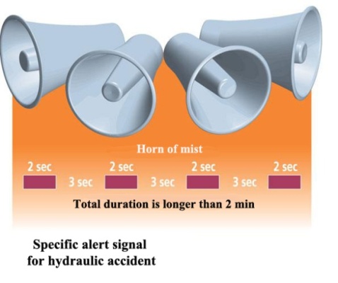
b) International special sign for dangerous works and installations .
During the accident:
Reach as soon as possible the elevated sites.
In order to identify hazards to which a given dam is prone, the following types of maps are relevant:
- Digital elevation maps for modelling potential flood effects.
- Geological maps showing the earth material on which the dam is erected.
- Active tectonic fault maps as possible earthquake and slow deformation sources.
- Seismic hazard maps, presenting the expected earthquake impact for a given site.
- Geomorphologic maps, delineating possible sources of mass-movement (e.g. landslides, debris flows).
A flood modelling map shows the height and speed of the flood wave and the flood dynamics in the time domain:
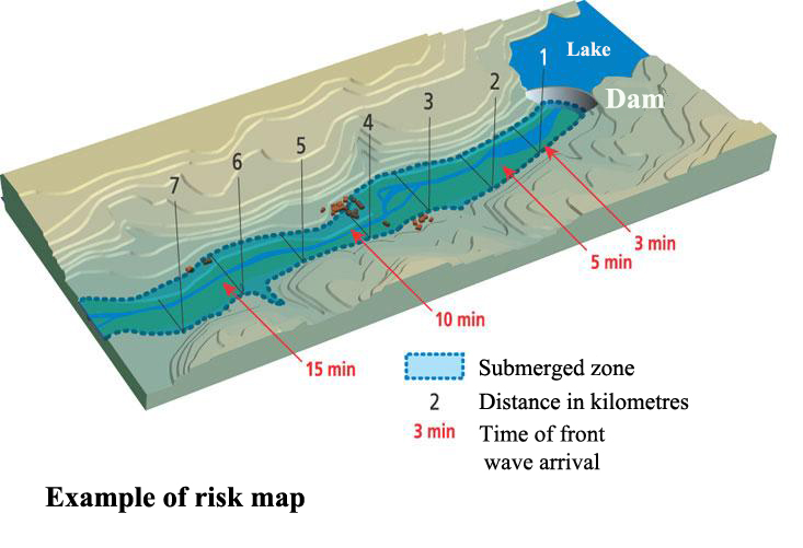
The main dam-related hazards are seismic shaking and overtopping due to landslide descent or large floods. The dam should be designed to resist the expected intensity of shaking (i.e. the so-called maximum design earthquake MDE). For calculation of the potential seismic impact, the maps of active tectonic faults of the area are compiled first. The intensity and recurrence interval of earthquakes generated by these faults are then assessed and finally the impact of the earthquake (the so called spectral ground acceleration) on the dam area is calculated. It is important also to take into account the site (soil) conditions and to know the natural frequency of shaking of a dam, because the dam is most vulnerable at this frequency.
If all this information is taken into account during design and construction of the dam, the seismic resistance of the dam structure is guaranteed.