Earthquakes

Natural Hazards

Earthquakes

Prepared by CERG – European Centre on Geomorphological Hazards – Strasbourg, France & the Editorial Board

An earthquake is a shaking and vibration of the ground caused mainly by the sudden breaking and movement of the tectonic plates in which the Earth’s crust is subdivided or by volcanic activity. Tectonic plates can include continental crust, oceanic crust or both; the earthquakes are usually concentrated along the edges of plates.

Potential damage in an earthquake can be produced by the following main hazards: ground shaking, ground displacement, tsunamis, flooding, landslides, fires etc.

Today, earthquakes prediction is not possible; nonetheless, scientific studies include activities aimed at understanding the mechanisms of the seismicity and assessing the probability of an earthquake.

An earthquake is a shaking and vibration of the ground caused mainly by a sudden release of energy in the Earth’s crust due to constraints suffered by rocks situated in deeper layers of the Earth, namely the solid mantle (included in the litosphere) and the molten mantle (the asthenosphere).

The earthquake’s energy release is at the Focus, some hundreds of meters below the Earth’s surface, on the fault plane. The Focus is the place where the first rupture is reached by the two portions of the crust, sliding one on top of the other (see the two black arrows) along the fault plane. The Epicenter is the vertical projection of the Focus on the surface. An earthquake’s energy waves propagate with a 3D spherical pattern in all directions (coloured circles). Source: http://earthquakesandplates.wordpress.com/

Earthquakes are characterised by their magnitude (seismic energy measured on the Richter scale) and their hypocentre (the underground fault movement location) and the epicentre (the surface location situated just over the hypocenter).

Considering two earthquakes releasing the same seismic energy, in general the deeper the hypocenter, the wider is the impact areas on the surface; large seismic faults with very high depths can produce very destructive earthquakes over hundreds of square kilometres.

Earthquakes can only be differentiated with respect to their origin:

Tectonic earthquakes

Large faults within the Earth’s crust accommodate differential or shear motion produced by the inner forces (called tectonic forces) responsible for the plate movements. When the energy accumulation along one or more faults becomes too high, rocks break suddenly, releasing energy through a rapid motion (the earthquake). Such faults can be very large (many kilometers) and they are responsible for the adjustment of movements between the various plates composing the Earth’s crust.

Different types of Plate Boundaries. This image is in the public domain because it contains materials that originally came from the United States Geological Survey, an agency of the United States Department of Interior. For more information, see the official USGS copyright policy. Source: Wikipedia

Volcanic earthquakes

Earthquakes can also occur in active volcanic areas as they are continuously deforming: such deformation is mainly produced through large and little fractures. In general, volcanic earthquakes release low energy and have a shallow focal depth.

Most earthquakes associated with young volcanoes are related to volcanic processes and may indicate that a quiet volcano is becoming active. Although large eruptions are often preceded by several significant earthquakes and many small rock breaking quakes, there is also a continuous release of seismic energy associated with the underground movement of magma. Volcanic tremor is a seismic vibration caused by the pulsing of pressurized magma and gas. The seismogram is of longer duration and more continuous than rock-breaking earthquakes of the same amplitude. Earthquake swarms recorded by seismometers and the ground deformation monitored by tiltmeters, help scientists determine the depth and location of flowing magma beneath the volcano, which in turn, provides scientists with information to issue hazard warnings. Source: USGS – http://gallery.usgs.gov/videos/660

Anthropogenic earthquakes

Anthropogenic earthquakes occur where human activity has played some part in bringing the system to failure. They can be classified in:

a) Induced earthquakes, where human activities produce stress changes, which are sufficiently large as to produce an earthquake. The rocks may not necessarily have been in a stress-state that would have led to an earthquake in a reasonably near future (in a geological sense!).

b) Triggered earthquakes, where a small perturbation generated by anthropogenic activities has been sufficient to move the rocky system from an almost-critical state to an unstable state. The seism would have eventually occurred anyway although probably at some later time. That is, these activities have advanced the earthquake clock. In this case, the additional perturbation stress is often very small in comparison with the pre-existing stress system. In recent years there has been an increasing attention toward earthquakes related to some kinds of human activities, such as traditional drillings for oil exploitation, the hydraulic fracturing (known as “fraking”) procedure to extract oil from shales or the over-exploitation, through years, of deep underground water. There is still no clear evidence of correlation between high magnitude earthquakes and such human activities; nevertheless, it is known that any kind of surface and / or underground perturbation is able to produce seismic waves, although of small intensities.

Example of how “fracking” works. Source: http://savesomegreen.co.uk/definition-frack/

Plate tectonics, a scientific theory created in the second half of the 20th century, states that the rigid earth’s crust (also called lithosphere) is broken up into “plates” moving on a low-viscous layer with a fluid mechanic behaviour (also called the asthenosphere). The very cause of earthquakes is thus the movement of such large plates which compose the outer shell of the Earth (earth’s crust).

When tectonic plates move under, over or slide past each other, earthquakes happen. Such motion can be either of millimeters, producing small shakings, or of meters, producing very violent earthquakes. Heat from the layers below the litosphere and the difference between the light density of lithosphere and heavy density of the underlying asthenosphere, explain such movements and are viewed as the most important source of energy driving plate tectonics. Difference in density also allows the asthenosphere to sink into the deep mantle at subduction zones.

Different types of Convergent Boundaries and subduction zones. Source: Wikipedia.

Tectonic plates can include continental crust, oceanic crust or both. Their movement is mostly due to the relative high density of lithosphere and the relative fluid mechanic behaviour of the asthenosphere.

This map by National American Space Administration shows the world areas in which tectonic late motion is more active. Consequently, in such areas Convergent, Divergent and Transform boundaries may be found where the main seismic and volcanic activity is registered. Source: Wikipedia, NASA

As it has been indicated in question 2, small-magnitude earthquakes can be also induced by human activities (ref. to Question 2 for the most common types), although no validated data is available so far to the scientific community, to identify some kind of correlation between those activities and big-magnitude quakes.

Earthquakes are strongly linked to the geological forces that build mountains and create oceans. Where plates meet each other, wide fault and fracture zones are concentrated. Earthquakes are thus usually concentrated along the edges of plates. Therefore, seismic risk mainly occurs in places where human settlements are located in:

  • Plate boundaries (convergent, transform and divergent, in order of expected seismic hazard)
  • Active volcanic areas, where the deformation of the volcano is responsible for low-energy/low-depth earthquakes usually threatening not very wide areas.
Distribution of earthquakes and volcanoes in the world. Credit: United States Geological Survey

Based on their geometry and on the field of forces responsible for plate movement, boundaries between plates can be schematically described by the following three simple characters:

  • Convergent boundaries (CB): plates collide so that subsequent compression buckles and deforms the Earth’s crust

Such a case is responsible for the creation of large volcanic arcs and mountain chains, depending mostly on the nature of the crust (continental and oceanic). CB are also described as “destructive” and are the seat of strong explosive volcanism and seismic activity.

  • Divergent boundaries (DB): plates move apart from each other.

New crust is created by the magma rising up through the fracture zones. Such boundaries are usually the place for quiet volcanism and seismic activity both in the oceanic spreading ridges and/or continental rift zones. As DB are the place of crust accretion, they are also named “constructive”.

  • Transform boundaries (TB): plates slide laterally along so-called transform faults.

Depending on the relative motion of the two plates, TB can then be named dextral or sinistral. As there is virtually no depletion or accretion of crust, such TB are also called “conservative”. They are mostly the seat of a large seismic activity. The San Andreas fault in California is the most known example of a transform boundary

Highly dangerous seismic zones are mostly seen in convergent and transform plate boundaries.

Types of Plate Boundaries. Divergent – Spreading Center – Constructive Margin. Characterized by ocean ridges and sea floor spreading. Convergent – Characterized by trenches and island arcs. Transform – Plates moving past one another along strike- slip faults. Source: http://geology.csupomona.edu

Lorem ipsum dolor sit amet, consectetur adipiscing elit. Ut elit tellus, luctus nec ullamcorper mattis, pulvinar dapibus leo.

Direct consequences of earthquakes are related to:

  • Ground shaking: The main danger in an earthquake is the effect of ground shaking on buildings as large ground shaking (or the deformation of the ground beneath them), can seriously damage buildings or bring them down. Moderate earthquakes can also produce liquefaction of loose rocks; water saturated sands or soils lose their bearing capacity and structural foundations “sink”. Strong surface waves can also produce landslides, mudslides, and avalanches on steeper hills or mountains due to heavy sollicitations;
  • Ground Displacement: Where subsidence or horizontal displacements take place, large damage is produced on structures and infrastructure built across the fault. If the fault zone reaches the surface, there is a great probability that damage will be wide and important.
The clock tower of Finale Emilia (Modena Province, Italy) half destroyed after the 20 May 2012 Mw5.9 earthquake that stroke the Emilia area. Source: http://www.thepostinternazionale.it/
Other important indirect consequences of earthquakes are:
  • Flooding: In the case of an earthquake, dam and river levee structures can suffer damages. If such damage are strong enough, water can be released and induced floods can damage structures and sweeping away or drowning people;
  • Tsunamis: Large seismic shaking of the sea bottom transfers the motion to the water; large waves are then propagating into the sea. Coastlines hit by Tsunamis can result in large damage for people and goods;
  • Fire: If gas and electric lines are damaged by an earthquake, fires can spread and add danger and destruction; examples of towns destroyed by earthquakes induced fires are San Francisco (1906) and Lisbon (1755).
  • Landslides: it is well documented that seismic shocks can trigger landslides, since seismic waves act to strongly increase the pore water pressure inside dormant and active landslide bodies, causing their sudden activation.
  • Ground cracks and liquefaction: the pore water pressure increase may cause ground cracks and liquefaction phenomena in loose sandy deposits, at shallow depths, if below a water table. These phenomena may induce, among others, structural instability to buildings due to sand spills and the consequent creation of voids beneath the foundations.

Earthquakes do not produce direct danger to people in open spaces, where no objects fall and there is no building collapse: in this case, people are not exposed to a large impact by an earthquake.

Ground cracks and liquefaction phenomena at San Carlo (Ferrara Province, Italy) induced by the 20 May 2012 Mw5.9 earthquake that struck the Emilia area (photo by D. Castaldini)

Consequences of earthquakes can be either reduced or increased based on individual behaviour and community development decisions (or, in some cases, lack of decision-making).

  • Behaviour: knowing well the emergency instructions and emergency plans is essential for people living in active seismic areas as in the case of alarm or crisis, everyone needs to participate in the right way to the efforts made by civil protection teams and authorities;
  • Development policies: adequate policies must be applied in seismic areas and thus local communities need to know the risk levels in the different areas and authorities have to adopt adequate seismic engineering rules for safe building, industry resilience and continuation of social activities.
Map of seismic hazard in Italy. Different colours indicate the excess in Peak horizontal Ground Acceleration (PGA) compared to normal Gravity Acceleration (g: 9,80 m/s2). PGA of 0,1g can damage built structures. Source: www.ingv.it

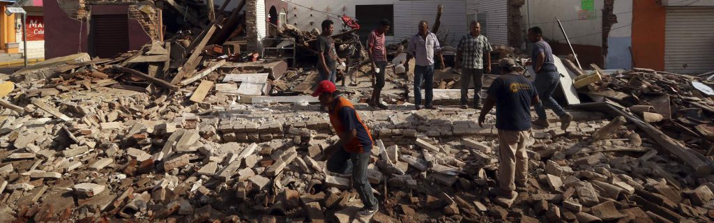
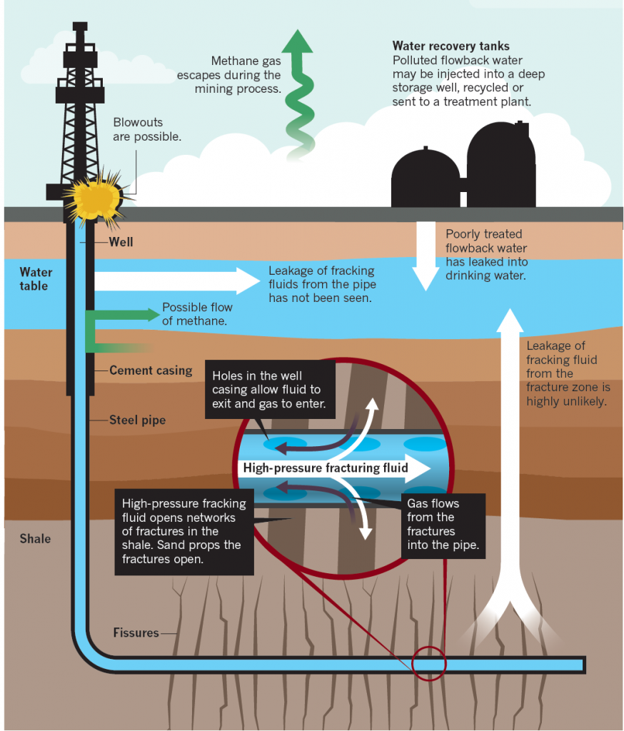
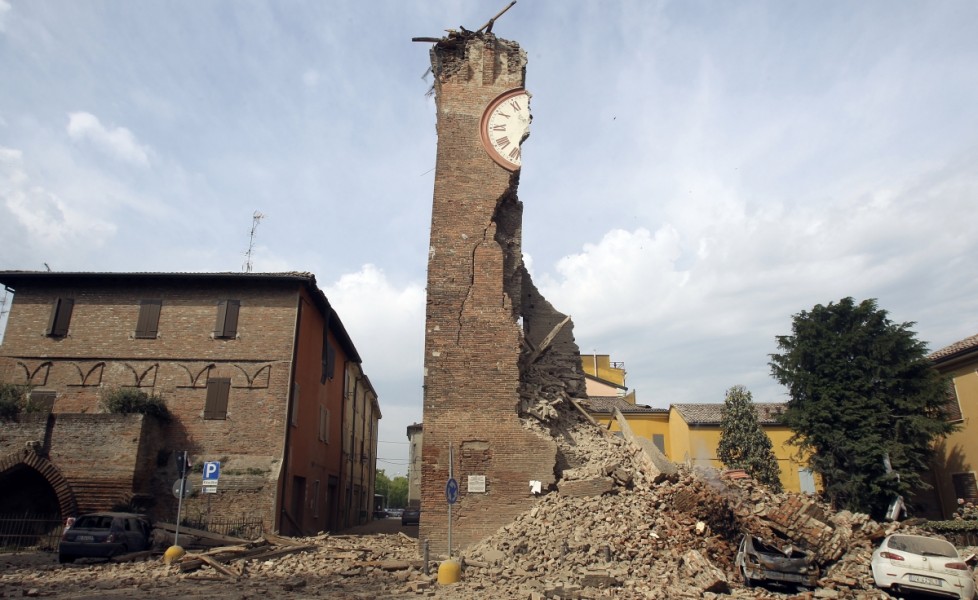
If behaviour and development policies do not adequately consider seismic risks, earthquake consequences can be significant and dramatic for individuals and the society as a whole.

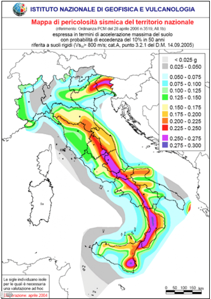
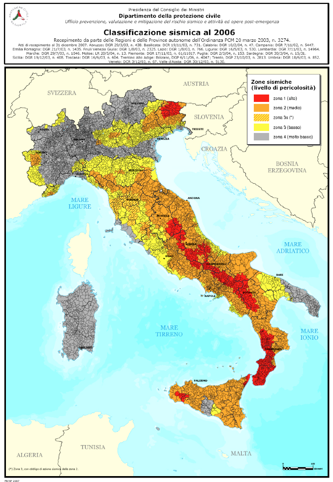
The choice of establishing economic, social and politically strategic elements and functions in a known seismic area has evident consequences; in the case of earthquakes, important elements and functions can be damaged or stopped, with negative consequence for the development efforts of a community.

However, adequate policy choices and structural engineering advancements allow society to live with a sufficient safety level in seismic areas: new structures and infrastructure can be built with accurate seismic safety criteria while older ones can be upgraded so that they resist in the case of an earthquake. The same applies for social and economic activities: prevention and preparedness activities can strengthen the community resilience and are the main tools for ensuring safety in seismic areas.

Research and development can also contribute to innovation in the field of earthquake safety: seismic safety is based on the ability to innovate in among other, science, engineering, land planning, institutional organization, emergency management.

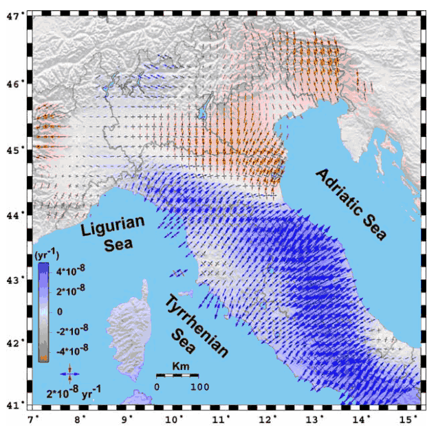
As earthquakes are not yet predictable, the only way to reduce risk in a seismic area is to lessen the vulnerability and the exposed value of human settlements through:

  • structural measures: seismic engineering building and upgrading;
  • non-structural measures: emergency planning, information, education, policy making, etc.
Seismic classification of Italian municipalities. Red: High hazard Orange: Medium hazard Yellow: Low hazard. Credit: Dipartimento Protezione Civile; Istituto Nazionale Geofisica e Vulcanologia, Italy

Seismic risk is a function of hazard, vulnerability and exposure. If vulnerability and level of exposure depend on human choices and behaviour, providing the possibility to influence them, hazard (the probability of occurrence of a major earthquake) depends on natural mechanisms (mainly underground rock deformation process in conditions of high stress, temperature and pressure) that cannot be influenced by human choices and behaviour. However, it must be pointed out that some small scale earthquakes can be triggered by human activity such as mining, dam construction, drilling for oil exploitation and “fraking”, to cite just a few; this does not mean that man is able to trigger the natural causes of earthquakes, such as the relative movement of crust blocks along faults, although it is reasonable enough to imagine that high-stress human actions (see nuclear explosions, for instance) could add energy to the overall energy budget within the Earth’s crust. The earthquakes due to human activities (anthropogenic earthquakes) can be classified as “Induced earthquakes” and “Triggered earthquakes” (see Question 2).

This cutaway through Earth’s subsurface shows many of the disturbances recorded by seismic sensors worldwide. Lawrence Livermore National Laboratory is responsible for developing tools that can quickly and accurately distinguish a nuclear test (foreground) from other seismic activity. Source: https://missions.llnl.gov/nonproliferation/nuclear-explosion-monitoring

Earthquake prediction is not possible as current scientific studies include activities aiming to understand the mechanisms of seismicity and to assess the probability of an earthquake in a given area, with a given magnitude and in a given time period; an earthquake prediction is thus only possible in probabilistic terms.

Based on the relevant studies in this field, we know:

  • Where seismic areas are localised;
  • the most dangerous earthquakes experienced historically in such areas;
  • the most energetic (magnitude) earthquakes in the areas;
  • the type of earthquake sequence typical for different areas (i.e. the seismic style);
  • the seismic pattern and sequences over the time in the different areas.
Strain rate field inferred from the velocity field. Red converging and blue diverging arrows indicate horizontal principal axes of shortening and lengthening respectively. Source: DPC-INGV-S3 Project “Short Term Earthquake prediction and preparation”

However, we often still don’t know:

  • Where exactly the next earthquake will occur (ipocentre / epicentre).
  • When exactly the next earthquake will strike.
  • Which will be the energy released (magnitude).
  • Which will be the preferred diffusion direction of the waves (as underground rocks have different composition, mechanic behaviour, etc.).
  • Which will be the surface site effects (due to surface rocks and morphological conditions).

The assessments and evaluations of seismic risk are mainly based on:

  • the study of the dynamics of the geological system in the area;
  • the study of the seismic history for that area (number, type, impact of earthquakes in pre-historical and historical times up today);
  • the assessment of the probability of different earthquake magnitudes and impacts; 
  • the identification and detailed analysis of areas and sites at risk;
  • the study of the quality and quantity of buildings and of the other exposed elements (industries, social activities) in order to assess their vulnerability to Earthquake and their exposed value.

The search for safety in seismic areas also uses tools to simulate earthquakes of different nature and violence to estimate consequent losses. Loss estimates should include the following main elements of knowledge:

  • physical damage expected for buildings of different nature (commercial, schools, residential, critical facilities, infrastructure and lifelines);
  • economic losses deriving from job loss, business interruption, costs for repair and reconstruction;
  • social consequences for people exposed to earthquakes: displaced people need shelter for the first emergency.

Such pre-disaster estimates are very important to develop mitigation policies and prepare the civil protection organization for emergency, response and recovery.

Nevertheless, there are experimental projects aimed at trying to predict short term earthquakes. One of those is the recent “INGV-DPC Project S3” developed in the framework of the agreement between the Italian National Department of Civil Protection (DPC) and the Italian National Institute for Geophysics and Volcanology (INGV). Its goal is to identify and evaluate effective procedures for short term (from hours up to some months) forecasting of destructive earthquakes (see the project’s web page for more details).

Seismic hazard describes the ground shaking level which can be produced by an earthquake. Seismic hazard assessment is thus the basic action to assess the actual risk.

The four basic elements of modern Probabilistic Seismic Hazards Assessment (PSHA) are:

  1. Earthquake catalogue: a catalogue of seismicity is created for earthquakes occurred in historical (before 1900) and instrumental (after 1900) periods of earthquake documentation and recording;
  2. Earthquake source characterization: it implies the definition of zones with similar seismic behaviour and space/time sequence of earthquakes (frequency, depth, focus);
  3. Strong seismic ground motion: studying ground shaking in relation to the distance to the source (hypocentre) generates as an output the macroseismic maps which describe the damages occurred during the different earthquakes;
  4. Computation of seismic hazard: calculation of the probability that an earthquake occurs in a given area.

The main effort to assess seismic hazard worldwide was made by the Global Seismic Hazard Assessment Program (GSHAP) launched in 1992 by the International Lithosphere Program (ILP) with the support of the International Council of Scientific Unions (ICSU) and endorsed as a demonstration program in the framework of the United Nations International Decade for Natural Disaster Reduction (UN/IDNDR).

The primary goal of GSHAP was to create a global seismic hazard map in a harmonized and regionally coordinated manner, based on advanced methods in probabilistic seismic hazard assessments (PSHA).

The GSHAP strategy was to establish Regional Centres responsible for the coordination and realization of the four basic elements of modern PSHA mentioned above. Website: http://www.seismo.ethz.ch/GSHAP/

So far there is no way to prevent earthquakes! Nevertheless, all that can be done is to reduce seismic risk, and this can be done through structural and non-structural measures (see Question 10 for details).

In order to mitigate the consequences of an earthquake it is necessary to reduce seismic risk, and this can be done through structural and non-structural measures.

Structural measures: application of engineering solutions to reinforce existing structures and to build new structures (houses, infrastructure, lifelines), etc.;

Non-structural measures: monitoring activities, seismologic studies, land management policies aiming to reduce the vulnerability and exposition of population in the risky areas, information and education campaigns, emergency management plans, rehabilitation and re-construction plans, etc.

As the risk rises with high levels of vulnerability and exposure, local societies need first to decide which risk level is acceptable for their development priorities.

The main ways to mitigate consequences of seismic risks are therefore based on:

  • assessment of the risk;
  • prevention measures: structural and non structural;
  • preparedness and response: emergency planning and management, drills, ability to deal with risk and foster resilience, etc.

The first essential rule is “know the seismic history of your area!” as very often people are not even aware of living in an at-risk area. Consequently, the knowledge of the risks of an area is the first safety measure for people.

REMEMBER!

Seismic hazard includes ground shaking and possible damage or collapse of the buildings in which we live, study, work. After an earthquake, infrastructure and lifelines can suffer disruptions and key public services (schools, hospitals, government buildings) might no longer function.

Before an Earthquake

  • Be aware of Emergency plans established by local and national authorities;
  • Prepare your emergency bag: some water and food, battery radio set, warm clothes and shoes, battery light, copy of the emergency plan.

During an earthquake

  • don’t run outdoors: stay under a bed, a table or close to a bearing wall of the building in which you are;
  • stay away from large objects (e.g. furniture, heavy lights) which can fall on you; stay away from glass, windows, outside doors and walls and anything that could fall, such as lighting fixtures or furniture;
  • stay inside until shaking stops and it is safe to go outside; people leaving buildings are exposed to falling debris, collapsing walls, flying glass and other falling objects;
  • check if somebody requires special assistance such as children, old people, people with disabilities, injured persons;
  • if you are outdoors, stay far from buildings, pillars, trees, etc.;
  • if in a car, stop it quickly in a safe area and stay inside: don’t stop near or under buildings, trees, overpasses and utility wires and avoid roads, bridges or ramps that might have been damaged by the earthquake.

After an earthquake

When you’re at home:

  • Be aware of aftershocks: these secondary shockwaves (which can occur in the first hours, days, weeks or even months after the main quake) are usually less violent than the main quake but can be strong enough to do additional damage to already weakened structures.
  • Open cabinets cautiously as objects can fall off the shelves;
  • Switch off, if you can, the gas and electricity and leave the area if you smell gas or any other chemicals.
  • Go outdoors slowly, taking care of the risk of debris and objects falling;
  • Don’t take the lift.

If you are trapped under debris:

  • Do not light flames (matches, lighters).
  • Do not kick up dust.
  • Cover your mouth with a protection (clothing, handkerchief).
  • Tap on a pipe or wall to give indications to search and rescue teams for locating you; shout only as a last resort as you could inhale dangerous amounts of dust.

When you’re outside:

  • Once in a safe place, listen to the latest emergency information on a battery-operated radio or on television.
  • Use the telephone only for emergency calls.
  • Stay away from damaged areas: return home only when authorities say it is safe.
  • Stay away from the beach as coastal areas can be exposed to tsunamis; a series of dangerous waves can be on the way, especially when a tsunami warning is issued by local authorities.
  • Help injured or trapped persons: call for help and provide them first aid when necessary but do not move seriously injured persons unless they are in immediate danger of further injury.
  • Check with authorities if the state of emergency is finished and follow their instructions to go back to the affected area.
Earthquake risk education in general leads to an enhanced perception of risk, better understanding of protective measures and less fear of a hazard. Source: http://drh.edm.bosai.go.jp

Broadly speaking maps used to tackle earthquake issues are of different types:

  • Scientific maps: scientific description of the geological structure and seismic details (type of geology, faults, peak ground acceleration zones, hazard maps, macroseismic maps showing impacts of past earthquakes, land morphology, etc.);
  • Emergency maps: describing the affected areas, the elements at risk, the escape ways, etc.;
  • Land planning maps: describing usages and policies that have to be given to the different land areas;
  • Risks and resources community-made maps: elaborated by local communities (schools, organizations) in order to acquire and spread the knowledge of the area, the awareness of the associated risks and of the existing resources (civil protection forces, meeting areas, safe sites, etc.).
Map of seismic hazard for the Near East region, expressing Peak Ground Acceleration expected at 10% probability of exceedance in 50 years, produced jointly by GSHAP and the UNESCO/USGS RELEMR project . Compilation of the GSHAP regional seismic hazard for Europe, Africa and the Middle East G. Grünthal, C. Bosse (GeoForschungsZentrum Potsdam, Germany), S. Sellami, D. Mayer-Rosa & D. Giardini (ETH Zurich, Switzerland) Source: http://www.seismo.ethz.ch

In general these different types of maps are available from:

  • Local authorities: Municipality, Prefectures, Civil Protection.
  • Universities, science centres and seismic institutes/observatories.
  • Local citizen organizations.

Information restrictions:

In some cases the access to some of the themes covered by emergency maps can be restricted as some of the information (such as locations of banks, large strategic infrastructure, military sites, insurance, industry, etc. …) has to be managed only by authorities and operational structures in case of crisis.

The 8 January 2006 Earthquake (Mw 6.7) Offshore Kythira Island, Southern Greece: Seismological, Strong-motion, and Macroseismic Observations of an Intermediate-depth Event Konstantinos I. Konstantinou, Ioannis S. Kalogeras, Nikolaos S. Melis, Moissis C. Kourouzidis, and George N. Stavrakakis Source: National Observatory of Athens (http://www.gein.noa.gr)
The Macroseismic intensity and the isoseismal map of the 26/12/2003 Bam earthquake, Iran Source: Bam (SE Iran) earthquake of 26 December 2003, Mw6.5: A Preliminary Reconnaissance Report Dr Sassan Eshghi1 and Dr Mehdi Zaré2 International Institute of Earthquake Engineering and Seismology, http://www.iiees.ac.ir