Volcanic Eruptions

Hazards

Volcanic Eruptions

Prepared by CERG – European Centre on Geomorphological Hazards – Strasbourg, France & the Editorial Board

Volcanoes can be described as openings in the Earth’s crust, through which molten rock, ash, and gases are emitted.

Volcanoes can be active or inactive.
Active volcanoes can be broadly divided into two main types: 

  • Explosive volcanoes which give rise to large explosions which can partially destroy the volcano, project high columns of rock materials (rock debris, rock blocks, ash, steam, etc.) in the atmosphere and subsequently falling down along the sides of the volcano, as well as generating lava flows, mud and debris flows along the sides of the volcano, earthquakes and noxious gas emission.
  • Effusive Volcanoes which give to among other, slowly moving lava flows, little explosions, ground deformations, lava fountains, gas and steam emissions.

Volcanoes can be described as openings in the Earth crust, through which molten rock, ash, and gases are emitted.

Volcanoes can be active or inactive.

Active volcanoes can be broadly divided into two main types:

Explosive volcanoes which give place to large explosions which can partially destroy the volcano, high columns of rock materials (rock debris, rock blocks, ash, steam, etc.) projected in the atmosphere and subsequently falling down along the sides of the volcano, as well as lava flows, mud and debris flows along the sides of the volcano, earthquakes, noxious gas emission.
Effusive Volcanoes which give to among other, slowly moving lava flows, little explosions, ground deformations, lava fountains, gas and steam emissions.

Source: United States Geological Survey (USGS)

Volcanic eruptions occur in areas where volcanoes are still active and where there are human settlements and activities. Simply speaking a volcano is described as active if it erupted:

  • in historical times: if its activity is described by historical documents;
  • in Holocene time: if its activity is not described by documents but scientific analysis indicates activity in the last 10,000 years.

Active volcanoes can be broadly divided into two main types:

Effusive Volcanoes

They bring about hazards as slowly moving lava flows, little explosions, ground deformations, lava fountains, gas and steam emissions.

Etna (Italy)
Etna (Italy)
Manua Loa (Hawaii)

Explosive volcanoes

They bring about large explosions which can partially destroy the volcano, high columns of rock materials (rock debris, rock blocks, ash, steam, etc.) projected in the atmosphere and subsequently falling down along the sides of the volcano, as well as lava flows, mud and debris flows along the sides of the volcano, earthquakes and noxious gas emission. The explosivity of an eruption usually results from gases expanding within a viscous lava or from water entering a magma chamber or channel. These eruptions are possible when a volcano is located in areas with large underground water reservoirs, in the sea or in lakes.

Source: “The Eruption of Vesuvius as seen from Naples, October 1822” from V. Day & Son. In G. Julius Poulett Scrope, Masson, 1864. Historical Draw from George Julius Poulett Scrope (1797-1876)
St. Helens (USA). Credits: photo by United States Air Force

Credit: U.S. Geological Survey. Department of the Interior, USA

Volcanoes are created due to the inner dynamics of the Earth. When underground melted rocks (magma) migrate through the fractures in the outer layer of the Earth (lithosphere) and reach the surface of the Earth crust a volcano is created.

A scheme of the Earth’s interior showing lithosphere and astenosphere in diverging and converging plate boundaries. Source: http://dilu.bol.ucla.edu/

The magma has very singular characteristics. Once it has reached the surface, it can have temperatures between 700 – 1200 °C and a density between 2300 – 2700 kg/m3. Viscosity is the attitude of the Magma to flow (high viscosity = low flow; low viscosity = high flow) and depends on its chemical composition. Magmas having high content of silica and gases and low iron and magnesium contents produce highly viscous lavas (rhyolites). Magmas with large content of magnesium (Mg), calcium (Ca) and iron (Fe) produce low viscous lavas (basalts).

As magma viscosity and gas quantity are the main factors controlling the eruptions, it can be stated that low viscous magmas (basaltic) can produce gentle eruptions with lava flows spreading slowly over large distances.

Highly viscous magmas (rhyolitic) can produce high pressures and strong deformations of the volcano, with large explosions and limited lava flows.

There are three main types of locations for volcanoes :

  • At the boundaries of plates
    • divergent plates: the progressive separation of the plates opens fractures in the crust through which magma rises out. In these zones magmas are in general basaltic (e.g. Mid-Atlantic ridge);
    • convergent plate: the colliding and overriding plates produce very high pressure and temperatures that melt the rocks and form the most dangerous volcanoes in the world. In these zones, in general, magmas are rhyolitic and rich in gases (e.g. the North Pacific area, Vesuvius in Italy);
  • Far from the boundaries of plates: Hot spots, rare volcanoes, with very deep magma reservoirs, giving less explosive basaltic volcanoes (e.g. the Hawaii islands).
Different types of Plate Boundaries – This image is in the public domain because it contains materials that originally came from the United States Geological Survey, an agency of the United States Department of Interior. For more information, see the official USGS copyright policy. Source: Wikipedia
Different types of Convergent Boundaries – Source: Wikipedia
Distribution of volcanoes and earthquakes in the world. Source: United States Geological Survey

The largest volcanic risks in the world are concentrated in densely populated areas located on the hills or near active volcanoes.

The most impressive example on Earth is the “Ring of Fire”, a 40,000 km long zone of frequent earthquakes and volcanic eruptions that encircles the basin of the Pacific Ocean, also called the circum-Pacific belt or the circum-Pacific seismic belt.

The Ring of Fire involves the western coast of North America continent and the Pacific Ocean islands: Kuril, Japan, Philippines. It accounts for 90% of the world’s earthquakes and 81% of the world’s largest earthquakes.

The next most seismic region (5-6% of earthquakes and 17% of the world’s largest earthquakes) is the Alpide belt which extends from Indonesian islands of Java and Sumatra through the Himalayas, the Mediterranean and out into the Atlantic.

The Mid-Atlantic Ridge is the third most prominent earthquake belt.

In Europe, volcanic risk is concentrated in:

  • the Mediterranean region: Southern Italy (Vesuvius near Naples, Stromboli and Vulcano in the Aeolian Islands, Etna in Sicily, etc.), Greece (Methana on the Peloponnese peninsula, Milos and Santorini in the Cyclades, Nisyros in the Dodecanese) and Turkey (Mt Ararat, Nemrut Dagi and Tendurek Dagi in Eastern Anatolia);
  • the Northern Atlantic Ocean region: Canary Islands (Teide, Teneguía, Tanganasoga), Açores Islands (Capelinhos, Mount Pico) and Iceland (with 130 volcanic mountains: Hekla, Eyjafjallajökull, Surtsey, etc.).

France has some active volcanoes but only in its overseas departments: the “Mount Pelée” in the Martinique and “La Grande Soufrière” in Guadeloupe (Carribean Sea), the “Piton de la Fournaise” in the Réunion island (Indian Ocean) and both submarine and emerged volcanoes in the French Polynesia (Pacific Ocean). The United Kingdom also has some in its overseas territories: for exemple, the very dangerous Soufriere Hills volcano is located on the island of Montserrat (Carribean Sea).

Directed blasts and pyroclastic surges usually move a large mass of air at very high speed, and produce death and sudden destruction of buildings, infrastructure and the environment.

Tephra (rocky materials projected in the atmosphere) can be responsible for deaths and injuries once they fall to the ground, covering large areas and damaging structures and the environment.

Volcanic ash exploded from a volcanic vent is less than 2mm in size, like small sharp glass-particles that damage anything they encounter. Volcanic ash is very harmful to the environment around the volcano: due to heavy ash-rains, people and animals may die by lack of oxygen and houses and buildings may collapse. Ash clouds can also be very dangerous for airplanes as they can damage engines and control instruments.

Volcanic gases can be noxious for human and animal health and for the natural environment.

Lava flows move slowly so they can hardly be a danger for human life, provided that adequate safe behaviour is respected.

One of more than 100 houses that were destroyed by the lava flow in 1990 at Kalapanais, a town and region in the Puna District on the Island of Hawaiʻi in the Hawaiian Islands. Source: http://en.wikipedia.org/wiki/Kalapana,_Hawaii

Pyroclastic flows, mudflows (lahars), debris avalanches and landslides produce large flows of water, rocks and debris along the hills of the volcano and can be very dangerous for human life. People caught in their path have a high risk of death from severe crush injuries, drowning or asphyxiation or can be burned in a pyroclastic flow. The only protective measures from such hazards in the case of an eruption are to evacuate the potentially involved people from the exposed area.

Volcanic earthquakes can produce human losses where the quality and maintenance of buildings are scarce. In such a condition, small volcanic earthquakes can already produce damage or destruction to buildings, killing and injuring people.

Fires produced by eruptions can be responsible for among other, destruction of forests, wood stocks, buildings, factories, producing large damage to urban and rural areas.

Eruptions can also produce volcanic tsunamis: large sea waves reaching coastal areas and going far inland causing death, large-scale damage and destruction of coastal regions.

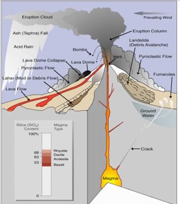
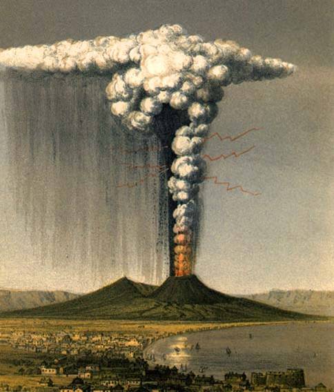
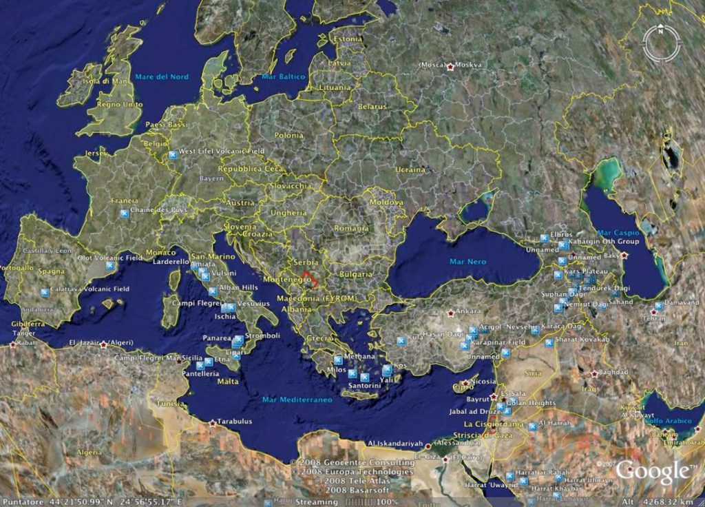
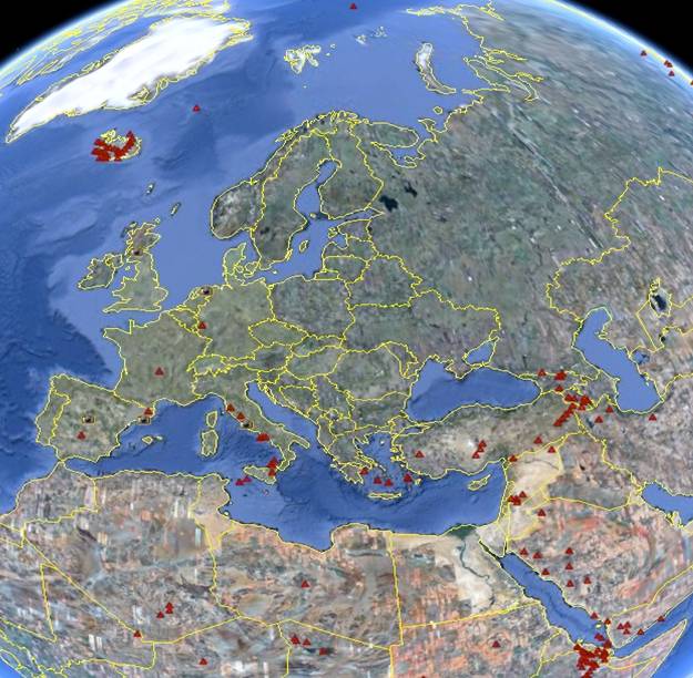
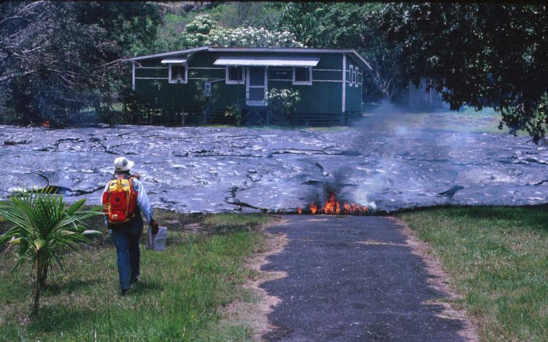
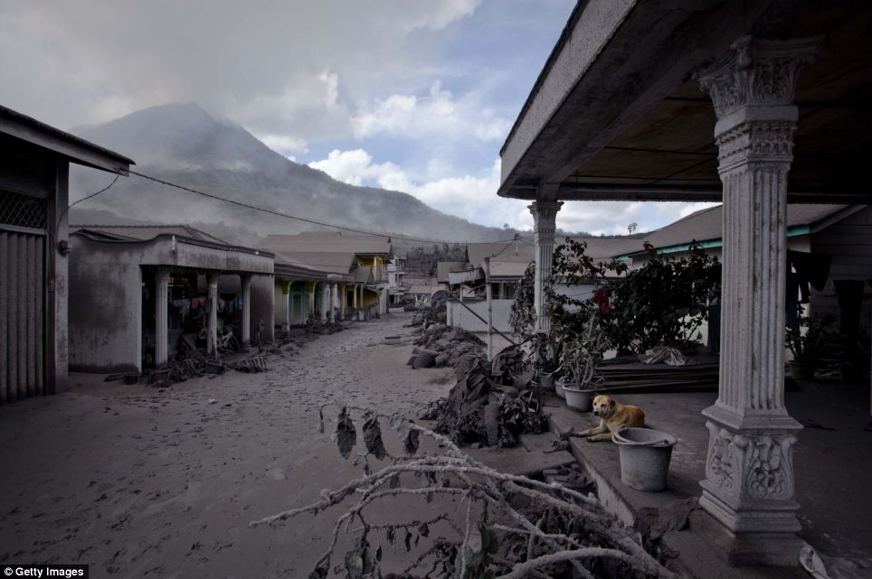
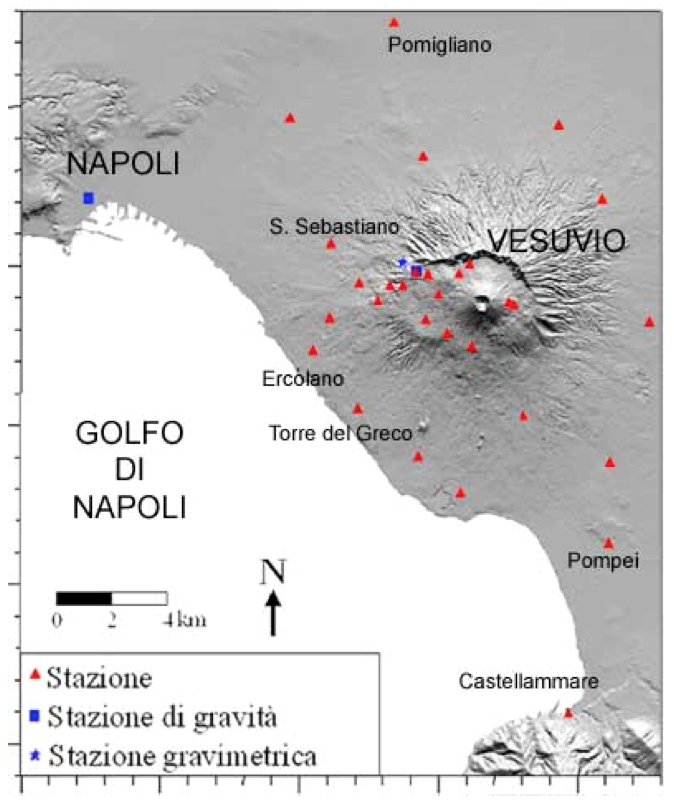
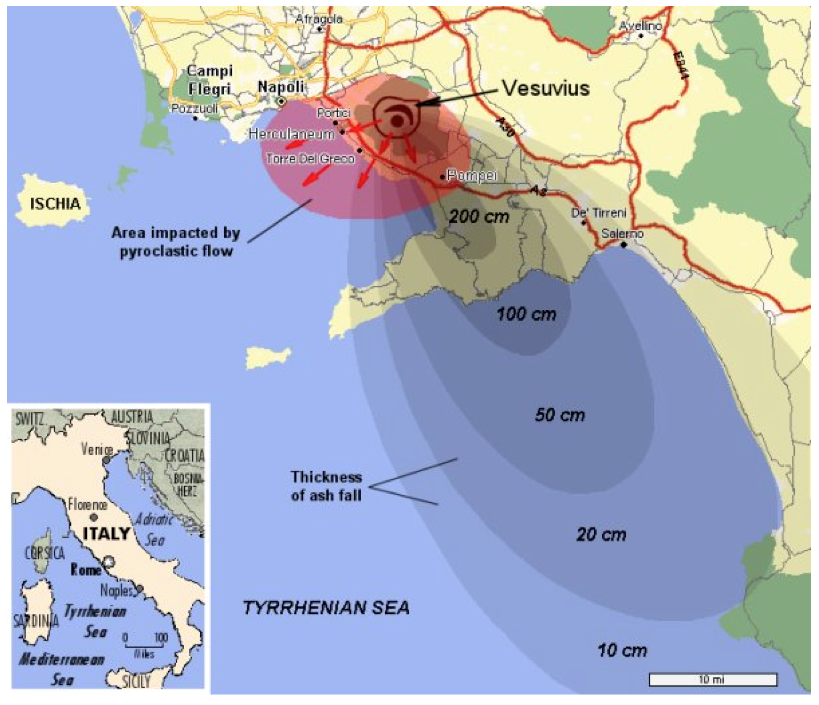
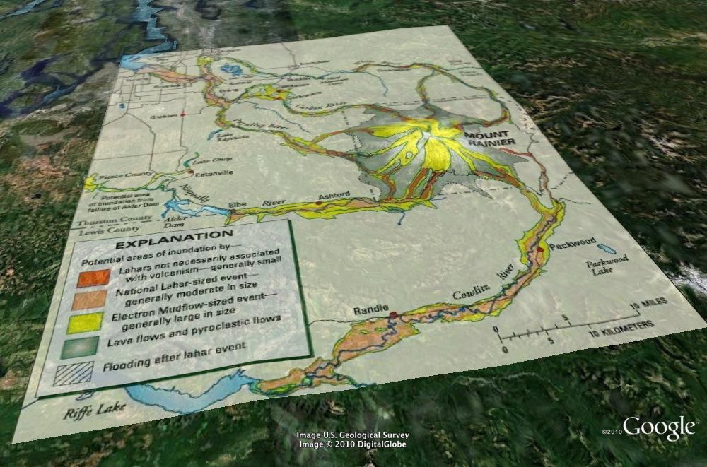
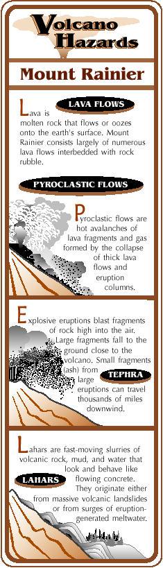
Volcanic eruptions can have strong negative effects for the environment. They can produce large destruction of the environment as lava flows and pyroclastic materials cover large portions of natural environments, destroying them for decades.

Furthermore, toxic gases emitted during strong activity can have an additional impact and in particular carbon dioxide emitted from volcanoes can have a significant impact on increasing greenhouse effect.

Emitted gases consist mainly of water vapour (H2O), carbon dioxide (CO2) and sulphur dioxide (SO2) and other gases typically found in volcanic ashes are hydrogen sulphide (H2S), hydrogen chloride (HCl, which becomes hydrochloric acid in contact with humidity), hydrogen fluoride (HF) and carbon monoxide (CO).

In particular, sulphur dioxide is converted in the stratosphere into sulphuric aerosols which reflect solar radiation absorbing heat but also take part in chemical reactions generating ozone destructive material, globally affecting the climate, and producing acid rains.

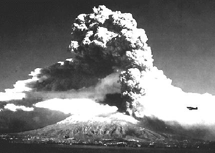
A typical example of a volcanic eruption that caused substantial environmental damage is the 1991 Mount Pinatubo eruption (90kms northwest of Manila in the Philippines), the second largest volcanic eruption of the twentieth century.

Large eruptions can cover prehistorical and historical remains, preserving them up to our days. Very famous examples of historical remains and archaeological sites damaged by volcanic eruption are known in the world: the Vesuvius area, inhabited since the Ancient Greek period, suffered eruptions with consequences on monuments and archeological sites (i.e. Pompeii, Herculaneum and prehistorical settlements near the Vesuvius).

Consequences can be lessened or increased based on individual behaviour and community development policies:

  • Behaviour: knowing well emergency instructions and emergency plans is essential for people living in active volcanic areas. In case of alarm or crisis, every person has to react in the right way to the efforts made by civil protection teams and authorities.
  • Development policies: adequate development policies must be applied in volcanic areas. Local communities have to know the risk levels in the different areas, authorities have to adopt and implement proper rules for buildings, industrial and agricultural activities.

If behaviour and development policies do not sufficiently consider volcanic risks, an eruption can have heavy consequences, dramatic both for individuals and for the whole society.ours and development policies don’t sufficiently consider volcanic risks, an eruption can have heavy consequences, dramatic both for individuals and for the whole society.

Volcanic eruption evacuation plan in Costa Rica – Source: http://livinglifeincostarica.blogspot.it/2013/03/volcano-evacuation.html

Volcanic hazard, as the probability of occurrence of a dangerous event, in a certain place, at a certain moment in time, cannot be influenced by human choices and behaviour since volcanic eruptions are purely nature-driven phenomena. But volcanic risk, as a function of hazard, vulnerability and exposure value, can be influenced by human behaviour: both vulnerability and exposure value depend on human choices and behaviour over the years.

It could be Pompeii: Weekend’s volcanic eruptions leave villages around Mount Sinabung in Sumatra looking eerily reminiscent of the ancient Roman city of Pompeii. Source: MailOnline 13 January 2014 – http://www.dailymail.co.uk/news/article-2538437/Volcanic-eruptions-leave-villages-Mount-Sinabung-looking-reminiscent-Pompeii-ancient-Roman-city-destroyed-Mount-Vesuvius.html

Volcanic eruption prediction includes activities aimed at understanding the functioning mechanisms of the volcano evaluating the probability of an eruption in a given area, with a given intensity (magnitude) and for a given period.

Prediction activities are carried out by scientists and experts as the assessments needed are based on:

  • the study of the dynamic of the geological system and of the volcano;
  • study of the history of the volcano;
  • estimation of the probability of different eruption types;
  • identification of areas and sites at risk.

Though there may be similarities in the general functioning of volcanoes, every volcano behaves differently and presents a specific hazard; it is thus very important for scientists to study and monitor each single volcano separately.

Volcanoes monitoring is made through:

  • Physical parameters: mostly used to detect the underground deformations induced by the displacement of the magma (seismic activity; ground deformation; geomagnetic, gravimetric and geo-electrical fields; water levels in sources and lakes, etc.);
  • Geochemical parameters: mostly used to detect magma changes generating its displacements towards the surface (gas, water and lava are analyzed to assess their flow rate and quantity as well as their composition and temperature).
The USGS monitoring network of the Yellowstone National Park volcano. Source: United States Geological Survey
The seismic monitoring network on vesuvius. Source: Vesuvius Observatory
Geodetic (ground deformation) network on Vesuvius. Source: Vesuvius Observatory
Gravimetric (differences in density of underground bodies) network on Vesuvius. Source: Vesuvius Observatory

By studying volcanic deposits, scientists can produce maps indicating the types of hazard that can be expected in a given area if the volcano erupts (hazard maps). Dating of volcanic deposits helps to determine how often an eruption may occur and what is the probability of an eruption in a given period of time (25, 50, 100, 1000 years).

Only through the monitoring of a volcano over a long period of time it is possible to detect physical and geochemical changes in the volcano, possibly announcing an eruption.

Such a probabilistic assessment of the volcanic hazard allows scientists and land developers to assess the risk level(s) and the public authorities to plan measures to reduce the actual risk.

Obviously, there is no way to prevent such an incredible natural force such a volcanic eruption.
Nevertheless, it is possible to prevent volcanic risk through:

  • Structural measures: these include protective walls, barriers, channels to divert lava and mudflows from inhabited areas and infrastructure, industrial and agriculture sites and the reinforcement of roofs to bear the ash weight.
  • Non-structural measures: these are based on volcano monitoring activities, land management policies aimed at reducing the risk for populations as well as information and education campaigns.

As the risk increases with the vicinity to the volcano, local communities need to decide first which risk level is acceptable for their development choices. Obviously, being as far as possible from a volcano is the best prevention measure from volcanic risk.

Based on the assessment of the probability of an eruption in a given place with a given intensity (magnitude) and for a given period, national and local authorities set up land development policies, establish emergency plans, support Civil Protection forces and promote adequate citizen behaviour concerning prevention and during emergency situations.

The impacts of the 79 A.D. eruption of Mt. Vesuvius. Source: mod. from Fig. 4-3 of J. Boer and D. Saunders, 2002, “Volcanoes in Human History.”

The main ways to mitigate consequences of volcanic risk are based on:

  • Prediction (cf question 8)
  • Prevention (cf question 9)
  • Preparedness and response (emergency planning and management, drills, ability to deal with risk and foster resilience)

Preparedness includes all measures aimed at lessening the vulnerability of social systems at risk. All available resources are involved in a comprehensive plan to be activated in case of an emergency: scientists, authorities, community representatives, media, intervention forces and organizations (i.e. Civil Protection teams, police, volunteers, etc.), health organizations and structures, private sector. Social communities are continuously informed about risks and risk evolution and it enables them to strengthen or maintain their capacity to properly react to a volcanic crisis (such as adequate precautionary individual behaviour and ability to follow instructions after a triggered alarm.

Mount Rainier Volcanic Hazard Management Google Earth Overlay. Source: http://www.geographyalltheway.com
Volcano evacuation route sign, near Mount Rainier, Washington, United States. Source: http://en.wikipedia.org

A first essential rule is to know the history of volcanic eruption in your area: very often people are not even aware of living in an ‘at risk’ area but such knowledge of risks is the first safety measure for them.

It must be recalled that volcanic hazard can also generate other hazards such as earthquakes, directed blasts, pyroclastic surges and flows, tephra, volcanic ashes and gases, lava flows, mudflows (lahars), debris avalanches, landslides, large fires and tsunamis.

If you live in a volcanic area, you must:

1. Before a Volcanic Eruption

  • Stay away from active volcano;
  • Be aware of emergency plans established by local and national authorities;
  • If you live near a volcano, active or dormant, be ready to evacuate at short notice.

2. During a volcanic eruption

  • Follow the evacuation order issued by authorities and evacuate immediately from the volcano area to avoid flying debris, hot gases, lateral blasts, and lava flows.
  • Check if somebody requires special assistance (e.g. children, old people, people with disabilities, injured persons, etc.).
  • Be aware of mudflows and landslides near stream channels, especially in case of prolonged heavy rains. As mudflows can move very fast, do not cross bridges or channels if a mudflow is approaching. Avoid also river valleys and low-lying areas.

In case of falling ash:

  • Stay away from downwind of volcano areas.
  • Listen to the radio; battery-powered radio or television is essential for listening to updated emergency instructions.
  • Avoid any contact with ashes: don’t breathe freely, use a dust mask or hold a damp cloth over your face to protect the respiratory tract, wear long-sleeved shirts and long pants.
  • Use goggles (safety glasses that protect the eye area) in order to prevent harm by particulates and chemicals substances and if needed, wear normal eyeglasses instead of contact lenses.
  • Stay inside until the ashes have settled and then avoid the danger of roof collapsing by clearing heavy ash from flat or low-pitched roofs and rain gutters.
  • Close doors, windows and all ventilation channels in the house (chimney vents, furnaces, air conditioners, fans and other vents);
  • Avoid driving during heavy ash fall and if really needed, drive slowly (less than 40-50 km/h);
  • Avoid also running car or truck engines as volcanic ashes can block them and damage moving parts.

3. After a volcanic eruption

  • Check with authorities if the state of emergency is finished and follow their instructions for the return to the affected area.
Mount Rainier — Living Safely With a Volcano in Your Backyard. Source: http://www.geographyalltheway.com

Broadly speaking, maps on volcanic hazard and risk are of different types:

  • Scientific maps: scientific description of the geological structure and volcanological details (type of rocks, fractures, morphology, etc., gas emission points, hot water sources, etc.). The volcanic hazard map (describing where the different hazards are likely to happen) is the most important scientific map as it is the basis of development plans and emergency plans made by authorities;
  • Emergency maps: description of the affected areas, the elements at risk, the escape routes, etc.;
  • Land planning maps: description of usage and policies that have to be applied to the different land areas;
  • Risks & resources community-made maps: description made by local communities (schools, organizations, etc.) of associated risks and existing resources (civil protection forces, meeting areas, safe sites, etc.) in order to raise people’s awareness.

In general, these different types of maps are available from:

  • Local authorities: Municipality, Prefecture, Civil Protection;
  • Universities, scientific centres and volcano observatories;
  • Local citizen organizations.


In some cases, access to some of the most sensitive data in emergency maps can be restricted as they must be managed only by authorities and operational structures in case of crisis (i.e. banks, health centres, large strategic infrastructures, military sites, industries, etc.).

Risk map of Merapi volcano, Indonesia. Center for Volcanology and Geological Hazard Mitigation (CVGHM). Source: http://miavita.brgm.fr
Simplified volcano-hazards-zonation map for Mount Hood, Oregon. For more information on hazard zones see text or for a more detailed map and description see Scott and others, 1997, Volcano Hazards in the Mount Hood Region, Oregon, U.S. Geological Survey Open-File Report 97-89. Source: http://pubs.usgs.gov
Volcanic Hazards Map for Rincon de la Vieja Volcano, NE Costa Rica. Source: http://www.geo.utexas.edu